لینکلن، اینگیلیس
ظاهر
City of Lincoln | |
|---|---|
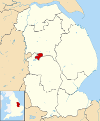
 Lincoln shown within Lincolnshire | |
| موختصاتلار: 53°13′58″N 0°32′16″W / 53.23272°N 0.537661°Wموختصات: 53°13′58″N 0°32′16″W / 53.23272°N 0.537661°W | |
| دۆنیا اؤلکهلری | United Kingdom |
| Constituent country | England |
| Region | East Midlands |
| Non-metropolitan county | Lincolnshire |
| Status | Non-metropolitan district, Borough, City |
| Admin HQ | Lincoln |
| Incorporated | 1 April 1974 |
| ایداره | |
| • نووع | Non-metropolitan district council |
| • اورقانی | City of Lincoln Council |
| • Leadership | Leader & Cabinet (Labour) |
| • MPs | Karen Lee |
| اراضی | |
| • City and Borough | ۱۳٫۷۸ sq mi (۳۵٫۶۹ km2) |
| مساحت درجهسی | 300th (of 326) |
| جمعیت (mid-2017 est.) | |
| • City and Borough | ۹۷٬۵۴۱[۱] |
| • درجهسی | 248th (of 326) |
| • شهر | ۱۳۰٬۲۰۰[۳] |
| • متروپولیتن | ۱۸۹٬۰۰۰[۲] |
| • Ethnicity | ۹۵٫۶% White ۰٫۸% S. Asian[۴] ۰٫۸% Irish ۰٫۵% Chinese ۰٫۵% African |
| دمونیم | Lincolnian |
| ساعات قورشاغی | یوتیسی 0 (GMT) |
| • یای (DST) | یوتیسی +1 (BST) |
| Postcodes | |
| تیلفون کودلاری | 01522 |
| ONS code | 32UD (ONS) E07000138 (GSS) |
| OS grid reference | SK9771 |
| وئب سایت | www |
لینکلن، اینگیلیس (اینگیلیسیجه: Lincoln, England) بریتانیادا بیر یاشاییش منطقهسیدیر
گؤرونتولر
[دَییشدیر]بیرده باخ
[دَییشدیر]قایناقلار
[دَییشدیر]| بو شهرلر ایله باغلی مقاله، بیر قارالاما مقاله دیر. بونو گئنیشلندیرمکله ویکیپدیایا کؤمک ائده بیلرسینیز. |


