ووبورن سندز
ظاهر
| Woburn Sands | |
|---|---|
 Woburn Sands High Street | |
| لوآ خطاسیماژول:Location_map-ین 522-جی/جو خطینده: Unable to find the specified location map definition: "Module:Location map/data/United Kingdom Milton Keynes" does not exist. | |
| جمعیت | ۲٬۹۱۶ (2011 Census)[۱] |
| OS grid reference | SP927360 |
| Civil parish |
|
| Unitary authority | |
| Ceremonial county | |
| Region | |
| اؤلکه | England |
| موستقیل دوولت | United Kingdom |
| Post town | Milton Keynes |
| Postcode district | MK17 |
| تیلفون کودو | 01908 |
| UK Parliament | |
| Website | Woburn Sands Town Council |
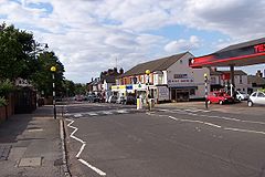
ووبورن سندز (اینگیلیسیجه: Woburn Sands) بریتانیادا بیر یاشاییش منطقهسیدیر سوْن نۆفوس تخمینلرینه گؤره 2916 نفر دیر. بۇ شهر اینگیلیس اؤلکهسینده یئرلشیب.
گؤرونتولر
[دَییشدیر]بیرده باخ
[دَییشدیر]قایناقلار
[دَییشدیر]- ^ Area: Woburn Sands (Parish): Key Figures for 2011 Census: Key Statistics. Neighbourhood Statistics. Office for National Statistics. آرشیولنیب اصلی نۆسخهدن on 2016-03-04. یوْخلانیلیب4 February 2013.
| بو شهرلر ایله باغلی مقاله، بیر قارالاما مقاله دیر. بونو گئنیشلندیرمکله ویکیپدیایا کؤمک ائده بیلرسینیز. |
