پورتیسهد و نورث وستون
ظاهر
| Portishead | |
|---|---|
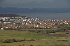
 Portishead viewed from Naish Hill | |
| جمعیت | ۲۳٬۶۹۹ [۱] |
| OS grid reference | ST465765 |
| Civil parish |
|
| Unitary authority | |
| Ceremonial county | |
| Region | |
| اؤلکه | England |
| موستقیل دوولت | United Kingdom |
| UK Parliament | |
پورتیسهد و نورث وستون (اینگیلیسیجه: Portishead and North Weston) بریتانیادا بیر یاشاییش منطقهسیدیر سوْن نۆفوس تخمینلرینه گؤره 23699 نفر دیر. بۇ شهر اینگیلیس اؤلکهسینده یئرلشیب.
گؤرونتولر
[دَییشدیر]بیرده باخ
[دَییشدیر]قایناقلار
[دَییشدیر]- ^ 2011 Census Profile (Excel). North Somerset Council. آرشیولنیب اصلی نۆسخهدن on 4 January 2014. یوْخلانیلیب4 January 2014.
| بو شهرلر ایله باغلی مقاله، بیر قارالاما مقاله دیر. بونو گئنیشلندیرمکله ویکیپدیایا کؤمک ائده بیلرسینیز. |


