کارشالتون
| Carshalton | |
|---|---|
|
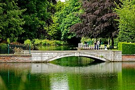
Top to bottom, left to right: the Upper Pond in Carshalton Village; the Sun public house in the conservation area; High Street, with All Saints Church in the distance; the Leoni Bridge and the Grove. | |
Location within لندن بزرگ | |
| جمعیت | ۲۹٬۹۱۷ (2011 Census. 3 Wards)[۱] |
| OS grid reference | TQ275645 |
| London borough | |
| شهرستان | Greater London |
| Region |
|
| اؤلکه | England |
| موستقیل دوولت | United Kingdom |
| Post town | CARSHALTON |
| Postcode district | SM5 |
| تیلفون کودو | 020 |
| Police | Metropolitan |
| Fire | سازمان آتشنشانی لندن |
| Ambulance | London |
| UK Parliament | |
| London Assembly | |
کارشالتون (اینگیلیسیجه: Carshalton) بریتانیادا بیر یاشاییش منطقهسیدیر سوْن نۆفوس تخمینلرینه گؤره 29917 نفر دیر. بۇ شهر اینگیلیس اؤلکهسینده یئرلشیب.
گؤرونتولر[دَییشدیر]
بیرده باخ[دَییشدیر]
قایناقلار[دَییشدیر]
- ^ Error on call to Şablon:cite web: Parameters url and title must be specified.
| بو شهرلر ایله باغلی مقاله، بیر قارالاما مقاله دیر. بونو گئنیشلندیرمکله ویکیپدیایا کؤمک ائده بیلرسینیز. |


