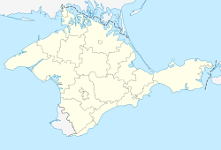
کوکتبل، روسیه
ظاهر
Koktebel
Коктебель Köktöbel | |
|---|---|
| موختصاتلار: 44°57′36″N 35°14′26″E / 44.96000°N 35.24056°Eموختصات: 44°57′36″N 35°14′26″E / 44.96000°N 35.24056°E | |
| دونیا اؤلکهلری | Disputed between Russia and Ukraine[۱] |
| جومهوریت | Crimea |
| بلدیه | Feodosia Municipality |
| اراضی | |
| • جمع | ۰٫۸۱۶۹ km2 (۰٫۳۱۵۴ sq mi) |
| اوجالیق | ۳۰ m (۱۰۰ ft) |
| جمعیت (2014) | |
| • جمع | ۲٬۸۰۷ |
| • سیخلیق | ۳٬۴۷۷٫۸/km2 (۹٬۰۰۷/sq mi) |
| ساعات قورشاغی | یوتیسی +4 (MSK) |
| تیلفون کودلاری | +7 36562 |
| Former name | Planerskoye (1945 - 1991) |
| Climate | Cfa |
کوکتبل، روسیه (اینگیلیسجه: Koktebel روسجا: Коктебель) روسیه اؤلکهسینده بیر یاشاییش منطقهسیدیر ۰٫۸۱۶۹ کیلومتر موربع مساحتی واردی. نۇفوس ساییسی اساسیندا 2807 نفر دیر.
قایناقلار
[دَییشدیر]- ^ This place is located on the Crimean peninsula, most of which is the subject of a territorial dispute between Russia, which administers the contested area, and Ukraine, whose internationally recognised boundaries include the contested area. According to the political division of Russia, there are federal subjects of the Russian Federation (the Republic of Crimea and the federal city of Sevastopol) located on the peninsula. According to the administrative-territorial division of Ukraine, there are the Ukrainian divisions (the Autonomous Republic of Crimea and the city with special status of Sevastopol) located on the peninsula.

